Two years after a 5.1 magnitude earthquake hit Sparta, North Carolina, professor Kevin Stewart’s research shows why the event was unique and important.
How often can you put your hand on an active earthquake fault? In the eastern U.S., nobody did that until two years ago.
That’s because no recorded earthquakes east of the Mississippi have produced a surface rupture, not even devastating temblors such as the 1886 earthquake in Charleston, South Carolina. Think of earthquakes, and images of cracked highways showing obvious fault lines come to mind. In the eastern U.S., those kinds of sights had not occurred until a 5.1 magnitude quake in Sparta, North Carolina, on Aug. 9, 2020, became the first to reveal a fault line.
On that morning, Carolina geologist Kevin Stewart rushed to Sparta. Stewart is a professor in the College of Arts and Sciences’ earth, marine and environmental science department. His specialty is researching structural geology such as faults and cracks in the Earth’s crust. He’s worked in the Apennine Mountains of Italy where there are active faults, in the Rocky Mountains and in western North Carolina.
Stewart was electrified by the U.S. Geological Survey’s notice of the Sparta earthquake, which people felt across North Carolina, much of the Eastern U.S. and west into Tennessee and Kentucky. He was on site by noon, along with colleagues from USGS and NC State. One of the most visible cracks was in the parking lot of a landscaping company, which rolled out an excavator to carefully dig along the fault line.
Stewart’s research in North Carolina has been on ancient faults that happened in some cases hundreds of millions of years ago. He’s particularly interested in the state’s long linear valleys or prominent lineaments, which in other parts of the world are typically associated with fault lines. In North Carolina, however, the Appalachians were considered a dead mountain range with little likelihood of discovering an active fault that could cause earthquakes.
Not anymore.
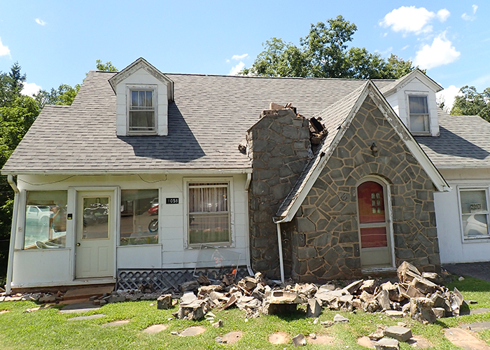
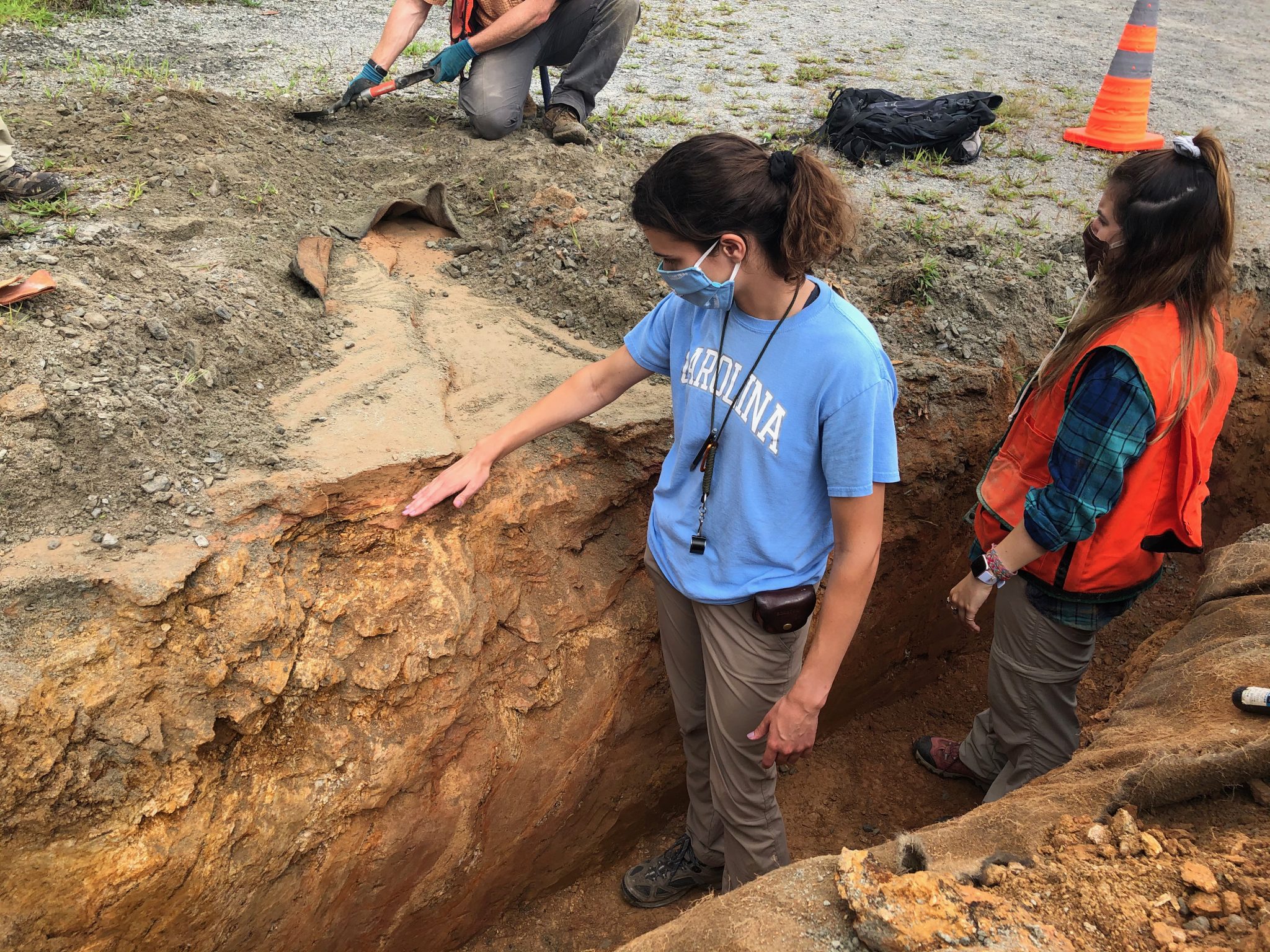
By the time Stewart arrived in Sparta, the damage was obvious: collapsed chimneys, foundations of houses and businesses cracked and off kilter, ruptures across roads and parking lots. The crack at the landscaping business resembled a step, a straight slice of about 10 inches. He could put his hand along the step and deeper into the fault after the excavator finished trenching. Some of his graduate and undergraduate students have joined him for field work along the fault line, placing their hands in the one-of-a-kind geological phenomenon.
“We realized that the earthquake fault actually had made it to the surface. This was the biggest earthquake in 100 years in North Carolina. Globally, it’s a moderate earthquake. Typically, only large earthquakes starting in the upper 5’s to lower 6’s cause a surface rupture.”
Stewart said that large earthquakes in 1811 and 1812 occurred on the Mississippi River line. After the 1886 quake around Charleston, South Carolina, no one found a surface rupture.
For the Sparta quake to be the first East Coast quake with a fault rupture is significant, Stewart said. Most earthquakes happen where two tectonic plates grind past one another. The areas where they make contact are plate boundaries. The San Andreas Fault in California is a well-known boundary between the Pacific Plate and the North American Plate.
“When there’s a known plate boundary, you know what your hazard is,” he said.
Some earthquakes, though, such as at Charleston and at Sparta, occur within a plate, in those cases the North American plate. Intraplate quakes, usually of lower magnitude, are hard for scientists to understand because they don’t happen along a clearly defined plate boundary.
At Sparta, scientists are learning more about intraplate quakes, which can cause enormous damage. “They’re hard to predict, but with this one rupturing the surface, we can see the fault,” Stewart said. “Without that fault, earthquake hazard analysis and earthquake hazard forecasting are a lot trickier.”
Better forecasting may help communities avoid the kind of damage seen in the Sparta area. To address residential damage caused by the quake, the state has paid $7.2 million on 525 claims, 60 of which are considered major. Damage to government infrastructure, which is at $7 million and rising, includes two Alleghany County schools and the county courthouse, Sparta’s water and sewer systems and Elkin’s fire department. The total of commercial damage is unknown as business owners file for insurance or other support on their own.
Stewart and others, including his students and researchers from the USGS, NC State and the North Carolina Geological Survey, mapped the fault, starting with the parking lot crack.
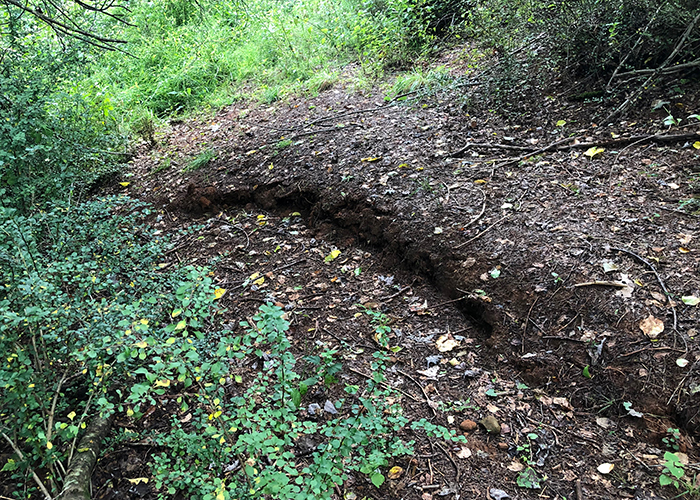
“We’ve walked a lot in the woods,” he said. “You find a spot where a block of ground has moved up and another has moved down. You keep walking in the direction where you think the fault ruptured to look for other spots.” The displacement at spots is sometimes a step of almost 30 inches.
They also relied on airplane-deployed lidar (short for light detection and ranging), a sensing method that uses laser pulses to determine the presence, shape and distance of objects, for precise topographic measurement. Researchers can digitally remove all vegetation from images to clearly show the fault line. Stewart compared pre-quake images of Sparta to post-quake images. “Subtract the old lidar from the new lidar, and it shows us where the ground has moved. It’s spectacular.”
They mapped a segment of the fault, a 1.2-mile arc curving northwest from Sparta and southeast toward Glade Valley. Where the surface rupture dies out, Stewart has been carefully searching for evidence of earlier earthquakes.
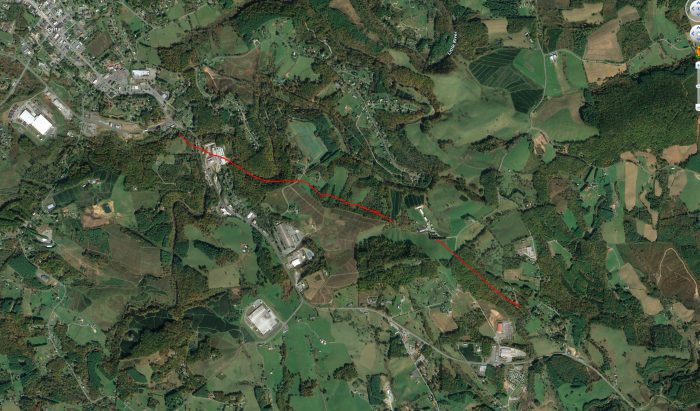
“We feel we’ve got evidence of other faulting episodes prior to August 2020. That probably takes the fault another 3 or 4 kilometers (another 2.5 miles),” he said. Stewart’s mapping efforts provide information that the USGS and state geological service is using for earthquake planning.
By Scott Jared, The Well