UNC undergraduate Mia Colloredo-Mansfeld, UNC PhD candidate Francisco Laso and UNC researcher Javier Arce-Nazario have engaged farmers in mapping their own land and shared aerial images with them in order to further the sharing of agricultural knowledge. This latest publication in the journal Drones highlights the value of using drones and aerial images with farmers in Galapagos and further explores the potential of high-resolution drone imagery for examining agricultural and agroforestry spaces, techniques, and practices. Aiding farmer interviews with aerial images of their farms encouraged farmers to address multiple subjects in an interconnected manner. Drone imagery thus supports studies of agricultural heritage not only by recording agricultural spaces but also by effectively revealing intricate agrarian knowledge and practices.
The use of drones for agricultural research tends to focus on the quantitative elements of the farm. Still, high-resolution images of agricultural areas can also be used in qualitative research to reveal processes that may not be immediately observable on the ground during interviews. Gifting farmers with a printout of an aerial image of their farms during interviews offered various advantages; aerial images of farms encouraged more interconnected discussions about management strategies at larger spatial and temporal scales than interviews with no aerial image aides. Drone images are a powerful participatory research tool that effectively engages farmers and helps scientists understand landscape elements from a farmer’s perspective.
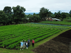 The images themselves are also valuable for farmers since most have never seen their farm from the air. Images that show how their labor has transformed the land can be an empowering and reaffirming element for farmers. Farmers valued the gifted printouts as tools for their personal objectives, including as a map to orient visitors around their land, a record to track the change of land cover over time, or as a promotional tool for their farm. View them here.
Colloredo-Mansfeld, M., Laso, F. J., & Arce-nazario, J. (2020). Drone-based participatory mapping: examining local agricultural knowledge in the Galapagos. Drones, 4(62), 1–19. https://doi.org/10.3390/drones4040062
By UNC Center for Galapagos Studies